

With traffic volumes decreased as non-essential workers have been staying home, the Los Angeles Department of Transportation (LADOT) and the Bureau of Street Services (StreetsLA) has taken the opportunity to complete a variety of much-needed road improvements on major city streets. Recently one of the first streets to be repaved under this program, 7th Street in downtown Los Angeles, has sparked some controversy among downtown residents and the general urbanist community about the City’s implementation of the Mobility Plan.
Mobility Plan 2035
As noted in a recent Streetsblog article, the City of Los Angeles often performs street improvements and lane striping modifications in conjunction with street repaving. Doing these together reduces costs and minimizes delays due to road construction. Due to the sheer number of streets and sidewalks which need repaving, a downside to this approach is that after a street is repaved, it is typically untouched for years, if not decades. Because of this, it is critical that the City executes Mobility Plan improvements when street repaving occurs. Unfortunately, this has not always been the case.
What is the Mobility Plan?
The Mobility Plan 2035 was a multi-year planning effort to update the City’s General Plan. Adopted in 2016 after a failed lawsuit, the Mobility Plan replaced the City’s old Transportation Element from 1999 and set forth a vision for an integrated network of bike facilities, enhanced pedestrian districts, transit corridors, and other transportation improvements.
The plan also reclassified street designations from highways and arterials to boulevards and avenues. Street designations have nothing to do with the name of the street; they instead designate the standard width of the paved street (the part that cars can drive on) and the public right of way (the full width of the street, including sidewalks). The term modified is used when the street’s paved width or right of way (also known as ROW) is more or less than the standard length set in the Mobility Plan. For example, Sunset Boulevard is designated as an Avenue I while a part of Grand Avenue downtown is designated as a modified Boulevard II. 7th Street is a modified Avenue II west of Los Angeles Street (80 foot ROW) and an Avenue II east of Los Angeles Street (86 foot ROW). So as you can see, there’s nothing confusing about these designations.
Implementation
Implementation of the approved Mobility Plan has been a slow, incremental process. Although the City worked with individual neighborhoods to develop the plan, they still receive backlash from many community groups about individual projects. Even the projects fully compliant with the Mobility Plan are subjected to additional review and much resistance. Ultimately, this increases the time and cost of implementation and makes the process more difficult. Check out the controversy over the Venice Boulevard bike lanes as an example.
Even with neighborhood approval, funds have to be allocated to specific Mobility Plan projects. These funds are not always on the same schedule as street repaving, which further complicates the implementation process.
What Does This Mean for 7th Street?
Now that LADOT has repaved 7th Street, the fear amongst advocates is that the new striping won’t include a protected bicycle lane. As stated in the Mobility Plan, 7th Street is supposed to have a protected bicycle lane between Catalina Street in Koreatown to Central Avenue. East of Central Avenue would be a Tier II bicycle lane, which is an unprotected bicycle lane. Currently, an unprotected bicycle lane exists west of Los Angeles Street and no lane exists to the east.
Failure to add the bicycle lanes on 7th Street now means it may be years before safe cycling is possible in the heart of downtown.
In response to concerns, LADOT has scheduled a meeting on Wednesday, May 6th to discuss the future of 7th Street. We’ll do a follow up post after the meeting. Until then, we have some of our own ideas for the 7th Street Corridor.
The Future of 7th Street
Today, cycling on 7th street is frustrating and dangerous. Frustrating may be a bit subjective, but dangerous is very much the reality. According to the City’s own data, 7th Street is part of the High-Injury Network. For those unfamiliar with the City’s Vision Zero program, the high-injury network is a small group (6%) of streets in the city which account for 70% of the deaths or severely injured persons due to automobile collisions. So walking and cycling are pretty dangerous under current conditions.
Which is a shame because 7th Street has so much potential to shine as a prominent, people friendly corridor in the center of downtown. Unlike Broadway, which councilmember Jose Huizar recently proposed making car free, 7th street has very few driveways and mid-block alleyways which would increase the conflict points between cars and all other road users. 7th Street is also home to numerous shops, restaurants, and bars which bring lots of life onto the sidewalks at all times of the day. Not to mention all of the various bus routes which operate on the street and are frequently stuck in traffic.
So what should be done? We suggest a two tiered approach. Phase 1 would provide immediate actions to complete the road resurfacing project and implement the Mobility Plan. Phase 2 would be a more visionary plan to create a prominent, car-free corridor which compliments future plans on Broadway, would enhance bus services, and accommodate bikes and pedestrians in a friendly environment.
Phase 1: Implement the Plan
Realistically, this will be the part that gets addressed at LADOT’s meeting because it is the most pressing. We can’t wait months for the street to be re-striped. So, we have provided the following street cross sections for a typical segment of 7th Street in downtown (Modified Avenue II) and the Arts District (Avenue II). Please note that these are conceptual and not to scale.
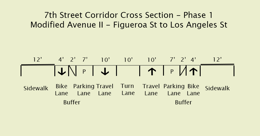
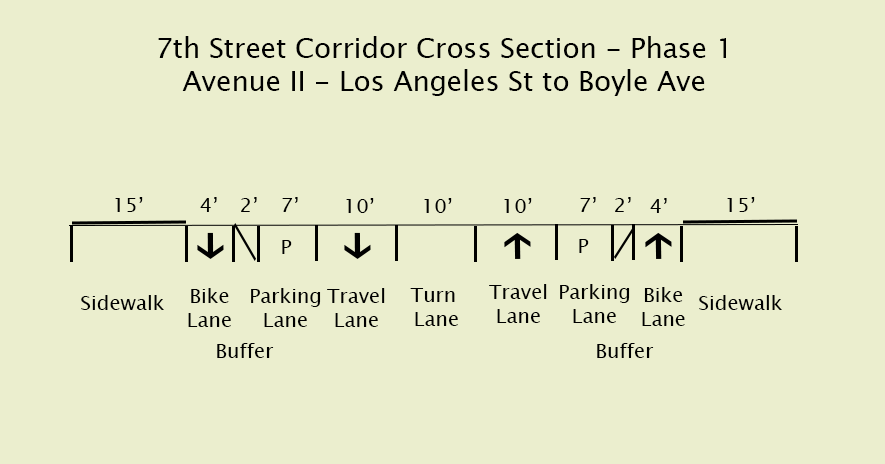
These are pretty straightforward and follow the same approach as seen on the Spring and Main Forward project completed last year. Bike lane next to the curb, a buffer lane with bollards, a parking lane, then travel lanes.
One key area which may impact the project is the availability of new bicycle signals to install at intersections. Traffic signals are not cheap purchases and would require working with the Automated Traffic Surveillance and Control group (ATSAC) to re-synchronize every intersection on 7th Street and possibly others.
Technically, the City could install the protected bicycle lanes without the traffic signals, but that could lead to collisions between turning cars and bicycles traveling behind parked vehicles. Based on other LADOT protected bicycle lane projects, such as MyFigureroa and the Spring and Main Forward Project, it seems unlikely that the City would allow a protected lane without proper bicycle signals. So, my prediction is that a funding source for the signals will need to be identified before the lanes can be installed.
Another issue which may factor into the decision making process is the current closure of the 6th Street Viaduct across the LA River. Traffic which would normally take this bridge has been diverted to 4th Street and 7th Street, so traffic volumes are higher than normal on these corridors. The bridge construction was supposed to be completed in late 2020, but that date has been pushed back to 2022. It may make sense to hold off on bicycle improvements east of Los Angeles Street until the bridge is completed and traffic resumes normal patterns.
Phase 2: Dream Big
Originally I was planning to write a multi-part series justifying the need to turn portions of Broadway and 7th street into car-free streets. Then 7th Street was suddenly repaved, and an upcoming meeting was scheduled and now we’re here. So this is a preview of some ideas to come when I eventually find time to write and get good enough at Photoshop to actually visualize plans (which may or may not ever happen).
The basic idea is to ban private vehicles on 7th Street from Figueroa Street to Los Angeles Street and augment bicycle and pedestrian infrastructure to connect the east and west sides of downtown. The improvements would also link to a proposed LA River bicycle path and Boyle Heights. Street trees, wider sidewalks with a uniform pavement style, public bathrooms, drinking fountains, restaurant seating, curb bulb-outs, and upgraded bus stops could all be included in the street transformation.
Below is a proposed diagram which shows an example of what the Modified Avenue II cross section could look like. Private cars would continue to be allowed east of Los Angeles Street, so the Phase 1 improvements would remain.
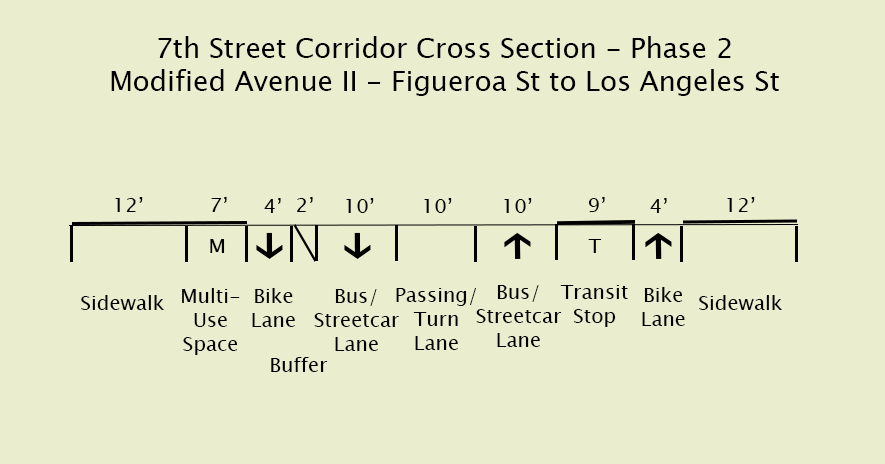
There are many benefits to this configuration. Buses would travel much faster through downtown, enticing additional riders. Bike lanes would be safer for people of all ages and abilities, plus any bicycle signals added during Phase 1 could continue to be used in Phase 2. The removal of parking along 7th Street means sidewalks could be widened to create bus islands and multi purpose spaces for restaurant seating, scooter and bikeshare parking, or other uses. Finally, it would provide many Angelenos with the freedom to move between downtown, the arts district, and Boyle Heights with numerous viable alternatives to driving a single occupancy vehicle.
When could this happen? Since it’s unlikely after this repaving, it could potentially be included as part of the proposed downtown streetcar project. The streetcar would travel on a portion of 7th Street and would require major structural changes to accommodate tracks and station platforms. There would also be an incentive to reduce traffic on the street, as we already know that riding trains in downtown traffic is not optimal.
It goes without saying that many of the Phase 2 improvements would come with a high cost, especially with modifications to the curbs, signals, and new bus and/or streetcar stations. While TPS can’t estimate the cost, or identify potential funding sources, we can say that these improvements would provide many benefits including improved connections within the downtown community, safer streets, and a beautiful, walkable corridor. While it’s hard to quantify these benefits, they’re important for meeting the City’s climate goals, encouraging healthier neighborhoods, and providing equity for those who rely on public transit or biking to meet their daily needs.
Conclusion
It is challenging but absolutely critical that LADOT continues to implement the approved Mobility Plan on 7th Street and all other streets anticipated to be repaved. Then, hopefully we can see even bigger and bolder plans for the urban core of downtown which will improve transit options, create beautiful open spaces, and decrease our collective car dependency.
POST SCORECARD (1 BEING THE LOWEST)
- Implementation Difficulty: Phase 1 – 1.5/3, pretty low cost especially for just the road striping. Phase 2 – 2/3, definitely higher cost, but similar improvements have been made to Figueroa Street.
- Photoshop Skillz: 2/3 – Graphics aren’t scaled so I’ll deduct some points there. Also the ones which didn’t make this post are currently a -5/3.
- Outrage Meter: Phase 1 west – 1/3. Phase 1 east – 1.5/3. Phase 2 – 1.5/3. Keep in mind this is scaled to all of the ideas on this site, some of which are much more radical or in areas which tend to object to bike/bus improvements. Downtown seems more friendly to these types of improvements.

[…] Anyone who has been on the DASH E or any Metro Line during rush hours knows just how slow bus travel can be on this corridor. Walking is oftentimes faster, which sounds like an exaggeration, but I have actually tried it and can verify. TPS hopes that the City considers making 7th Street an exclusive bus, bike and pedestrian corridor to address this issue, as discussed in our first post. […]
LikeLike