
Starting a new, hopefully weekly, post called Content of the Week (or the COW). For the first COW, we’re focusing on the maps provided in the Metro Next Gen Bus Study.
Efficiency in transportation can be measured using many different methods. Trips taken, vehicle miles traveled, number of vehicles, delay, capacity, and so on. Each is important from its own technical analysis standpoint. However, one seemingly underutilized method for analyzing transportation improvements is the trip duration, aka the time it takes to go from A to B.
What I like about the Reach Map is that you can easily see what is accessible within an hour of your location at different times of the day. There’s a ton of data that goes into making these maps, so it makes sense you don’t see them often. But they’re important because time is one of the biggest factors an individual might consider when deciding when to travel and what mode to take.
When comparing the existing network vs the proposed changes, immediately you notice how much further you’ll be able to travel in the same amount of time. For a lot of people, this is easier to understand than talking about headways, queue jumps, peak hour bus lanes, and other changes proposed in the update. It immediately provides a quantifiable answer to the question “How will my trips be affected?”
It also highlights the unfortunate fact that many areas still don’t have great regional transit access outside of a few miles of their starting point.
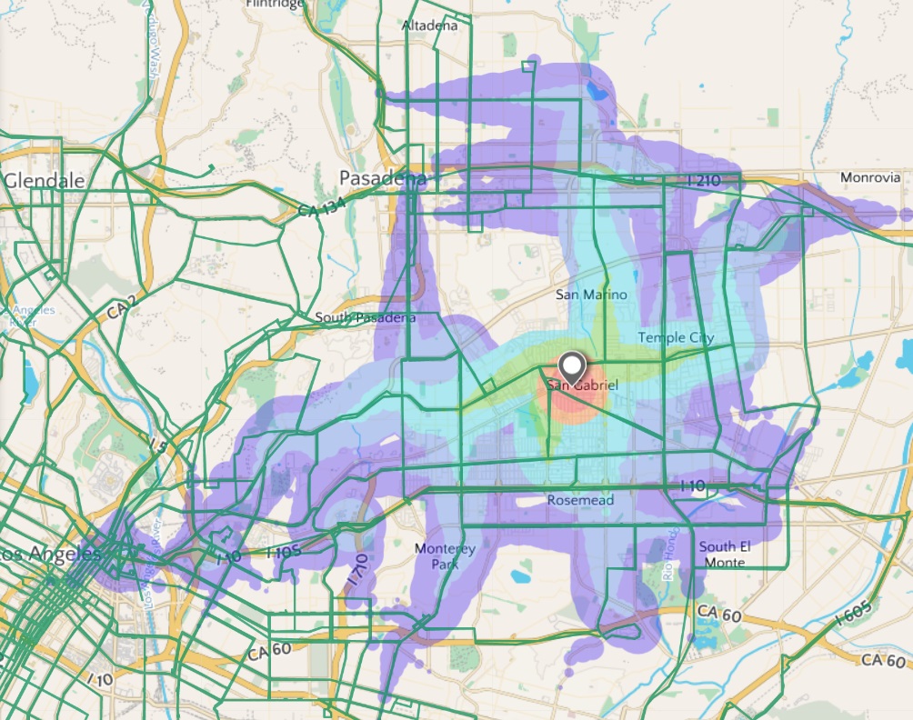
Take a look at the proposed changes for a starting location in San Gabriel (shown above). It’s an improvement from the existing network, but getting to Old Town Pasadena, which is only 5 miles away, would take an hour during the off-peak midday period. That same trip by car would take maybe 20-30 minutes in moderate traffic, saving people time they could spend with their families or doing other things.
Obviously Metro has lots of data about their riders and desired trip destinations, so maybe there isn’t enough demand for making that route a more direct bus line. San Gabriel is only one example though, as many neighborhoods in LA County also have limited regional transit access. Thus, residents in these areas will probably drive for most tasks.
These are the neighborhoods where Metro needs to provide improved regional transit access, especially if Metro is considering congestion pricing and other measures intended to disincentivize driving. Taking an hour bus ride with multiple transfers to go five miles isn’t a viable alternative to driving.
The maps are great though and I’m glad Metro is using a variety of tools to provide a complete look at all the proposed changes. I truly believe that the final version will greatly improve bus service from what we have now. I just hope that more neighborhoods will see transit accessibility that looks like downtown or better.
